
 admin
admin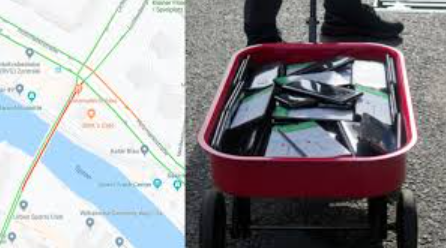
How To Create Fake Google Maps Traffic Using Multiple Smartphones
How To Create Fake Google Maps Traffic Using Multiple Smartphones
Understanding How Fake Google Maps Traffic Works
Google Maps is one of the world’s most popular navigation platforms, developed by Google to help users find locations, view streets, and receive real-time traffic information. Millions of people rely on the service every day for driving, cycling, walking, and public transportation. One of the reasons Google Maps is so accurate is its ability to collect anonymous location and speed information from smartphones and navigation devices. By analyzing this data, Google Maps can estimate traffic conditions and suggest faster routes. According to Google’s official documentation, navigation data helps improve traffic conditions, disruptions, and estimated arrival times for everyone.
Official Google Maps documentation:
https://support.google.com/maps/answer/10565726
Because Google Maps relies heavily on aggregated user data, researchers and security experts have long been interested in understanding whether traffic conditions displayed on the map can be manipulated.
How Does Google Maps Detect Traffic?
Google Maps does not rely solely on traffic cameras or road sensors. Instead, it combines several sources, including:
- GPS location data from smartphones.
- Navigation data from users.
- Historical traffic patterns.
- Information from transportation agencies.
- User reports from Google Maps and Waze.
- Machine learning and AI algorithms.
When many devices move slowly along the same road, Google Maps interprets this as congestion and marks the road with yellow, orange, or red lines depending on the severity of the slowdown.
This crowdsourced approach has made Google Maps one of the most accurate navigation systems available today.
Can Multiple Smartphones Create Fake Google Maps Traffic?
The idea behind fake Google Maps traffic is relatively simple.
If many smartphones with location services enabled move slowly together on the same road, the navigation system may interpret the cluster of devices as slow-moving vehicles. As a result, Google Maps could temporarily classify that area as congested and reroute other users.
This concept became widely known after an unusual experiment conducted in 2020.
Simon Weckert’s Famous Google Maps Experiment
In 2020, German artist Simon Weckert from Berlin conducted an experiment that attracted worldwide attention.
Instead of using cars, he placed 99 smartphones inside a small handcart and slowly walked through empty streets in Berlin. Every phone had Google Maps running.
As the devices moved together at walking speed, Google Maps began showing heavy traffic congestion on roads that were actually empty. Some streets changed from green to dark red, causing navigation systems to redirect drivers to alternative routes.
The project, called “Google Maps Hacks,” was designed as an artistic demonstration of how digital systems influence the physical world. The experiment highlighted how much modern navigation services depend on crowdsourced data.
How Was the Experiment Performed?
The process involved:
- Gathering 99 smartphones.
- Running Google Maps on all devices.
- Connecting each phone to the internet.
- Placing the phones inside a wagon.
- Walking slowly through selected streets.
Because all devices appeared to be moving slowly together, Google Maps interpreted the movement as a traffic jam.
Why Did It Work?
Google Maps estimates traffic conditions based on several factors:
Device Density
A large number of active devices in the same location indicates that many road users are present.
Speed Analysis
Slow-moving devices are often associated with traffic congestion.
Historical Traffic Data
Google compares current conditions with previous patterns to determine whether a delay is unusual.
Artificial Intelligence
Machine learning systems analyze and combine all available information to improve accuracy. Recent improvements continue to enhance route prediction and traffic analysis.
Is It Still Possible Today?
Google continuously updates its algorithms to detect anomalies and improve the reliability of traffic information.
Since Simon Weckert’s experiment, Google has introduced numerous improvements and AI-based enhancements that make the system more resistant to unusual behavior. Although traffic information still relies heavily on crowdsourced data, modern algorithms are better equipped to recognize irregular patterns and combine information from multiple sources.
Therefore, reproducing the exact results seen in 2020 may not be as straightforward today.
Why Was Simon Weckert’s Project Important?
The experiment was not intended to cause disruption. Instead, it raised important questions about:
- Trust in digital systems.
- Dependence on algorithmic decision-making.
- Data privacy.
- Vulnerabilities in crowdsourced platforms.
- The influence of technology on cities and transportation.
It demonstrated that the digital information displayed on maps can affect real-world traffic flow and people’s behavior.
Researchers Continue Studying Traffic Data
Scientists and transportation researchers continue to use Google Maps data for traffic forecasting and urban planning.
Academic studies have shown that Google Maps traffic information can help predict congestion and improve transportation models, especially in developing countries where traditional traffic-monitoring infrastructure may be limited.
These studies show how valuable crowdsourced traffic data has become for modern cities.
How Google Maps Improves Traffic Accuracy
Today, Google Maps uses a combination of:
- Artificial intelligence.
- Historical travel data.
- Real-time GPS information.
- Road sensors.
- Reports from transportation authorities.
- Waze community reports.
- Anonymous user contributions.
This combination allows Google Maps to provide accurate estimated arrival times and route recommendations for millions of drivers worldwide.
Privacy and Location Data
Many users wonder how much information Google Maps collects.
Google states that location information used for navigation is aggregated and anonymized. Users can control privacy settings, disable Location History, or use Incognito Mode for Maps to limit saved activity. However, Incognito Mode does not make users completely anonymous.
You can learn more about Google Maps privacy controls here:
https://support.google.com/maps
Could Hackers Use Multiple Smartphones to Manipulate Traffic?
Security researchers have explored how crowdsourced systems can be influenced. However, modern navigation platforms employ increasingly sophisticated algorithms and multiple data sources to minimize manipulation.
While the 2020 experiment demonstrated an interesting weakness, Google continues to improve its systems to make them more reliable and resilient.
As with many technologies, the purpose of these studies is not to encourage abuse but to understand how complex digital systems work and how they can be strengthened.
The Future of Google Maps Traffic Detection
Google Maps is evolving rapidly. New AI-powered features and immersive navigation technologies are making route guidance more intelligent than ever. Recent upgrades provide better lane guidance, improved 3D visuals, and more accurate route predictions.
As artificial intelligence becomes more advanced, traffic prediction systems are expected to become even more accurate and resistant to manipulation.
Conclusion
The idea of creating fake Google Maps traffic using multiple smartphones became famous after Simon Weckert’s 99-phone experiment in Berlin. His project demonstrated how crowdsourced data can influence real-world navigation and highlighted both the strengths and limitations of digital mapping systems.
Although Google Maps primarily uses anonymous location information from millions of users to estimate traffic conditions, the platform has continued to evolve with AI-powered improvements and additional data sources that make traffic predictions more accurate and robust.
Today, Google Maps remains one of the most sophisticated navigation tools available, helping billions of people around the world travel more efficiently while continuously adapting to new technological challenges.
External References
- Google Maps Help Center: https://support.google.com/maps
- Google Maps Navigation Data: https://support.google.com/maps/answer/10565726
- Simon Weckert Project: https://radicaldata.org/projects/google-maps-hacks/
- WIRED Article: https://www.wired.com/story/99-phones-fake-google-maps-traffic-jam/
- The Guardian Article: https://www.theguardian.com/technology/2020/feb/03/berlin-artist-uses-99-phones-trick-google-maps-traffic-jam-alert
Follow Us
Stay connected with us on social media to receive updates on our latest posts.
Follow us on: Facebook | Instagram



)
)